


No Fly Zone
No Fly Zone介绍
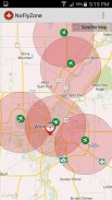
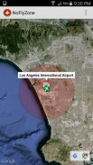
This app contains over 46,000 airports around the world which can be displayed quickly and easily when flying RC models. When flying RC/UAV's commercially, these areas are considered "No Fly Zones" based on your geographic location.
For example when flying UAV's in Canada, Transport Canada has set a 9km no fly zone around Airports without proper legal authorization.
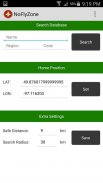
By default this app sets a 9km radius around Airports and will display all airports within 30km of your marker.
These settings can be adjusted depending on geographic location and rules in your area.</div> <div jsname="WJz9Hc" style="display:none">这个程序包含了世界各地的46000多的机场,可以方便快捷地飞行RC模型时显示。当商业飞行RC /无人机,这些地区被认为是基于地理位置的“禁飞区”。
例如飞行的无人机在加拿大时,加拿大运输部已成立各地机场9公里的禁飞区没有合法授权。
默认情况下此应用程序套左右的机场9公里的半径,并显示在您的标记30公里的所有机场。
这些设置可以根据地理位置和规则在您所在地区进行调整。</div> <div class="show-more-end">
No Fly Zone - 版本3.0
(22-04-2016)No Fly Zone - APK信息
APK版本: 3.0程序包: com.reelmedia.NoFlyZoneNo Fly Zone的最新版本


同类应用


您可能还会喜欢……


